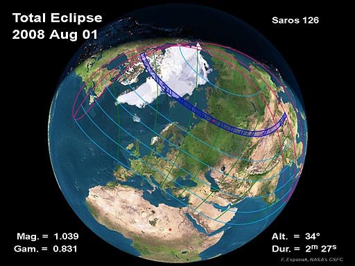
On Friday, 2008 August 01, a total eclipse of the Sun is visible from within a narrow corridor that traverses half of Earth. The path of the Moon’s umbral shadow begins in northern Canada and extends across Greenland, the Arctic, central Russia, Mongolia, and China (Espenak and Anderson, 2006). A partial eclipse is seen within the much broader path of the Moon’s penumbral shadow, which includes northeastern North America, most of Europe, and Asia (Figures 1 and 2).
The path of totality begins in northern Canada (Figure 3), where the Moon’s umbral shadow first touches down in the territory of Nunavut at 09:21 UT (Universal Time). Along the sunrise terminator in Queen Maud Gulf, the duration is 1?min 30?s from the center of the 206?km wide path. Traveling over 9?km/s, the umbra quickly sweeps north across southern Victoria Island, Prince of Wales Island, and Northern Somerset Island (Figure 4). The shadow’s northern limit clips the southeastern corner of Cornwallis Island and just misses the high Arctic town of Resolute. The ~200 residents of this isolated settlement will witness a partial eclipse of magnitude 0.997 at 09:26 UT with the Sun 7° above the horizon.
Continuing on its northeastern trajectory, the umbra crosses Devon Island and reaches the southern coast of Ellesmere Island where it engulfs the tiny hamlet of Grise Fiord. The duration of total eclipse here is 1?min 38?s. The central line cuts across Nares Strait as the shadow straddles Ellesmere Island and Greenland (Figure 5). Canada’s remote outpost Alert, the northernmost permanently inhabited place on Earth, lies near the northern limit of the eclipse track and experiences 43?s of totality with the Sun at 16° altitude at 09:32 UT.
The northern half of the path encounters the open Arctic, while the southern half cuts across the many fjords of northern Greenland. Leaving the coast of Greenland, the shadow reaches its northernmost latitude (83° 47?) at 09:38 UT as it traverses the landless Arctic Ocean. Slowly curving to the southeast, the track passes between Franz Josef Land and Svalbard where George Land and Kvitoya Island are cut by its northern and southern limits, respectively (Figure 6). By the time the central line reaches the northern coast of Novaya Zemlya (10:00UT), the duration is 2?min 23?s with the Sun at 31° (Figures 7 and 8). The track crosses both the island and the Kara Sea before reaching the Yamal Peninsula and the Russian mainland at 10:10 UT (Figure 8).
The instant of greatest eclipse occurs at 10:21:07 UT (latitude 65° 39?N, longitude 72° 18?E) when the axis of the Moon’s shadow passes closest to the center of Earth (gamma = +0.8307). When totality reaches its maximum duration of 2?min 27?s, the Sun’s altitude is 34°, the path width is 237?km, and the umbra’s velocity is 0.908?km/s. The Russian city of Nadym (pop.ulation ~46,000) lies nearby and only loses 1?s of totality because of its short distance (~14?km) from the central line (Figure 9).
During the next hour, the Moon’s umbra works its way across central Asia. The shadow gradually picks up speed and its course changes from south-southeast to nearly east at its terminus (Figure 7). Central Russia is sparsely populated, however, there are a few small cities in the path of totality including Megion, Nizhnevartovsk, and Strezhevoy (Figure 10).
Novosibirsk, Russia’s third most populous city (pop. ~1.4 million), lies only 18?km from the central line. The midpoint of Novosibirsk’s 2?min 18?s total eclipse occurs at 10:45 UT with the Sun’s altitude at 30° (Figures 10 and 11). Three and a half minutes later, Barnaul (pop. ~600,000) is plunged into a 2?min 16?s total eclipse.
As the umbral shadow exits Russia, it briefly encompasses the intersection of four nations: Russian, Kazakhstan, China, and Mongolia. After crossing the Altay Mountains, the center of the track follows the China-Mongolia border for several hundred kilometers while the central duration and the Sun’s altitude decrease (Figure 12). During this period, the central line crosses from Mongolia to China to Mongolia and finally back to China where it remains until the end of the eclipse track.
From Altay, China, the total eclipse begins at 10:59 UT and lasts 1?min 25?s with the Sun 25° above the horizon. Across the border, western Mongolia is very sparsely populated and the Altan Mountains bring cloudiness to the area. Ten minutes later, the umbra just misses Hami, China (pop. ~137,000) where a deep partial eclipse of magnitude 0.998 occurs at 11:10 UT. About 140?km east of Hami, Yiwu lies just 25?km southwest of the central line (Figure 13). Inhabitants of this small town witness a total eclipse lasting 1?min 56?s with the Sun at an altitude of 19°. This region in northwest China is noteworthy because it offers some of the most promising weather prospects along the entire eclipse path. Its position between the Gobi Desert to the east and the Talikmakan Desert to the west spares it from the monsoon systems that affect much of Southeast Asia during the summer months.
During the final 10 min of the umbra’s track, it quickly sweeps across northern China as the duration of totality and the Sun’s altitude continue to decrease. Juiquan (pop. ~73,000) lies in the path near the southern limit, but it still experiences a total eclipse lasting 1?min 08?s at 11:15 UT (Figure 14). Further east, the major city of Xi’an (pop. ~3.9 million) straddles the southern limit where maximum eclipse occurs with the Sun just 4° above the horizon (Figure 15). From the central line, 106?km to the north, the duration of totality still lasts 1?min 35?s. Seconds later, the Moon’s shadow lifts off Earth and the total eclipse ends (11:21 UT). Over the course of 2?h, the Moon’s umbra travels along a path approximately 10,200?km long and covers 0.4% of Earth’s surface area.

